
Cities have the capability of providing something for everybody, only because, and only when, they are created by everybody.
– Jane Jacobs, The Death and Life of Great American Cities (1961)
The true dynamism of American cities comes from the connectedness of its institutions and the people within it. Considered one of the most residentially segregated cities in the United States today, Louisville lags far behind most American municipalities in regards to the relationships between the communities that comprise it. Though segregation policies in cities across the United States were implemented during the same time period and ultimately for the same reasons, Louisville has not been as successful as other cities in “un-doing” the ramifications of residential segregation and reconnecting its communities. This is due to decades of explicitly racist infrastructure policies created by White urban planners and politicians. It is these infrastructure decisions that have quite literally left a lasting impression on Louisville and allowed segregation in the city to persist today.
The State of Residential Segregation in Louisville Today
Residential segregation is no secret in Louisville. Most Louisvilians are well aware of the “Ninth Street Divide,” which essentially divides the city into Black and White residential areas. However, it is the origins of residential segregation in Louisville that many people are unfamiliar with.
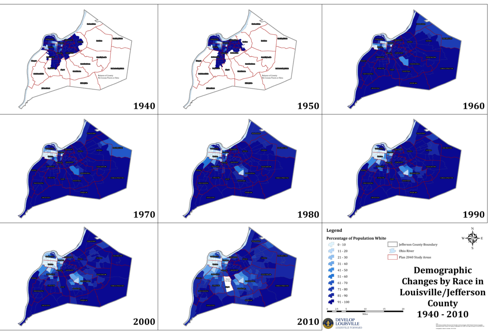
The city is starkly segregated; according to data from the 2020 U.S. Census, neighborhoods in West Louisville are almost entirely populated by Black families, and likewise, most areas of East Louisville are exclusively populated by White families. If you travel to the East side of the Ninth Street Divide, you will see lively cultural mainstays of the city like Bardstown Road, NuLu, downtown, and Waterfront Park. Property values are higher, the economy is flourishing, there are lower crime rates, and median income is higher. On the other hand, if you travel to the West side of the Ninth Street Divide, you will see communities plagued by poverty, lack of economic development, low property values, crime, and pollution.
However, it wasn’t until the last couple decades that the city has been as segregated as it has. Up until the 1960s, the population of Louisville was relatively racially heterogeneous in the downtown area, and many White people lived in neighborhoods in the West End. Starting in the mid-1950s, though, the construction of massive infrastructure projects like I-65, Spaghetti Junction, and other modes of urban renewal caused a drastic shift in the city’s demographics.
Racism Was Built into Infrastructure
Though June 29th, 1956 seemed like an inconsequential day to the American public at the time, the events that took place that day would come to radically alter their way of life and propagate segregation in cities. On that Friday 65 years ago, President Dwight D. Eisenhower signed the Federal-Aid Highway Act into law. This project would ultimately become the largest public construction undertaking in U.S. history, with the expansion of U.S. interstates to 41,000 miles and authorization of $25 billion that would be disbursed to the states between 1957 and 1969 for their construction.
Though the legislation was intended to connect U.S. cities to one another with interstates and in some ways did that − oftentimes racist, White urban planners would design the interstates to be jammed through cities. This, in turn, chopped cities into pieces, creating disconnected areas and isolating people from one another at a time when public transportation was not widely available.
The decision by these racist urban planners to have highways cut right through inner-cities was by no means accidental. At the time, one of the primary goals of interstates was to spread wealth to White people that were living in suburbs on the outskirts of the metropolitan area. In order to do so, city planners and government officials often saw bulldozing through majority-Black neighborhoods as the path of least resistance for their ambitious infrastructure projects, with absolutely no thought of how it would impact these communities. Though intended to spread prosperity and create economic opportunity, these interstates really only did so for White people.
Racist urban planners and policymakers justified wiping out Black neighborhoods and businesses with a discriminatory practice known as “redlining”. This is where bank lenders, insurers, and government agencies—most notably the Home Owners’ Loan Corporation—would draw red lines on maps to indicate neighborhoods with minority occupants, deeming them “high-risk for mortgage lenders.” Federal regulators would only back mortgages and subsidized housing in neighborhoods designated “low-risk” (usually White neighborhoods), while low-income, Black, and immigrant neighborhoods were often designated “high-risk” explicitly on the basis of race. This was a prominent practice in the mid-20th century in Louisville and many other urban areas throughout the country.
This ultimately led to lower property values in majority-Black neighborhoods. As a result, these areas were considered “blight” and were the first to go during construction of the interstates during the late 1950s. Predominantly Black neighborhoods designated as “hazardous” on redlining maps were three times more likely than the best-rated neighborhoods to be subjected to interstate highway placement. Building these interstates through redlined neighborhoods, in turn, forced the majority of Black families and Black business owners to relocate. This was intentional on the part of the people who designed them.
Urban renewal also came about as a result of redlining. Urban renewal consisted of clearing out of blighted areas in inner cities to create opportunities for higher class housing, businesses, and more. This was driven by the idea of bringing White businesses into downtown and White customers along with them, and primarily included the building of stadiums, shopping centers, and entertainment districts. Urban renewal ultimately intensified housing shortages and perpetuated segregation by pushing entire communities of Black citizens away from downtown and westward in Louisville, further away from downtown and the White neighborhoods on the East end of town.
Construction of these major highways and urban renewal both forced the relocation of Black families and thus contributed to segregation.
How Does this Pertain to Louisville?
If you look at a road map of Louisville today, you will notice it is chopped into several pieces by Interstates 64, 65, 71, and the Watterson and Gene Snyder expressways. Most notably dividing the city is Interstate 65. Built in late 1956 just following the passage of the Federal-Aid Highways Act, I-65 runs North to South right through the heart of downtown Louisville.
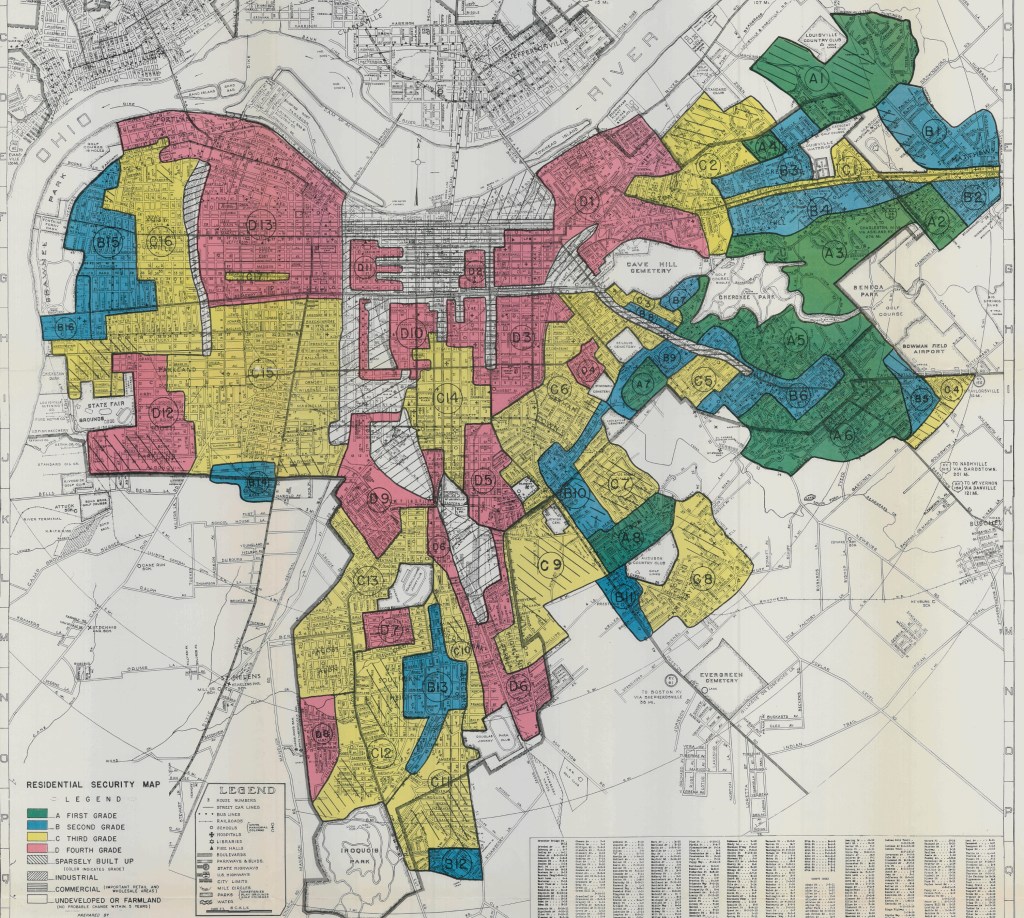
In the Home Owners’ Loan Corporation map of Louisville in 1938 above, note that areas D3 (Smoketown) and D5, which are colored red and deemed “hazardous,” are where I-65 runs through today. These were predominantly Black communities at the time.
One of the hardest-hit by the construction of I-65 was the Black community of Smoketown. Located just slightly east of where I-65 sits today, Smoketown housed the majority of Black businesses and neighborhoods in Louisville prior to the 1960s. This area was once densely populated and served as a focal point for Black Louisvillian culture. However, with the construction of I-65 in Louisville during the late 1950s, much of Smoketown had to be cleared and its residents relocated to the West end. By the 1960s, Smoketown saw a massive population loss, as most of the shotgun houses located there had been demolished for urban renewal projects. During the late 19th century, Smoketown had a population of roughly 15,000, however, as of 2000, the population of Smoketown was 2,116, a decrease of nearly 85%.
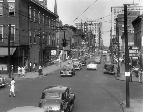
And it wasn’t just the residents of Smoketown that had to be relocated, but also many of the businesses in the heart of the Black business district. Located on what used to be formerly known as “West Walnut Street” (now known as Muhammad Ali Boulevard) stretching from 6th to 13th Streets, the Black business district dated back to the late 1800s and included over 150 businesses. This included restaurants, banks, news and printing services, barber shops, theaters, and even some nightclubs. The area thrived from the 1920s up until the 1950s, and served as a business, social, and cultural gathering place for Black Louisvillians during this time. However, in the 1960s, most of the businesses and resident homes were demolished for the sake of urban renewal and other infrastructure projects. Today, if you drive down Muhammad Ali Boulevard just west of the Ninth Street Divide, you see will little but parking lots, a car dealership, a senior citizen apartment complex, and a couple old abandoned buildings. All of this area used to be the Black business district.
Source: UofL Archives.
What Can be Done to Combat Decades of Intentional Residential Segregation?
Racist infrastructure, redlining, urban renewal, combined with the private actions of prejudice and discrimination, has kept the two halves of Louisville segregated for decades now. But how do we develop equally effective government actions to reverse this residential segregation?
When public schools were officially desegregated, as long as the ruling was enforced, the next day, children could go to the school in their neighborhood. When buses were desegregated, the next day, Black Americans could sit wherever they pleased. However, residential segregation like we see in Louisville is a much more of a difficult problem to solve; we can’t just up and move people from the West End to the suburbs of East End where many Black Louisvillians were once excluded from buying homes.
What we can do ─ and what we need to make sure policymakers can guarantee ─ is that any current or newly developed zoning policies don’t reinforce segregation patterns. Land use policies that limit new multifamily development, like large-lot zoning and historic districting, commonly perpetuate segregation. If we barred these kinds of exclusionary zoning policies, this would permit developers to build modest apartment buildings or single-family homes in predominantly White suburbs that currently prohibit all of those things and encourage desegregation.
And though urban interstates serve the rapid movement of suburban and inter-city bus and truck trips, such roads are not as useful for the short urban trips of locals. Instead, their purposefully discriminatory placement decided on decades ago has kept cities like Louisville segregated. Many advocates argue that cities should remove their tangled mess of interstates, or at least have the interstate bypass the downtown area to where it does the least harm to communities. However daunting highway teardown projects may seem, many U.S. cities like Portland, San Francisco, and Milwaukee have actually completed such undertakings with success.
And advocates have considered doing just that here in Louisville; starting in 2005, a grassroots citizen group called 8664 (“ax 64”) campaigned to remove I-64 along the waterfront and replace it with a smaller parallel parkway. The four-lane parkway would be designed with pedestrians in mind, with frequent crossings, street trees on both sides, and a green median along its center. Although able to handle vehicle traffic, its primary goal would be to facilitate access to the waterfront to those who live, work, and visit downtown. The idea was popular; more than 11,000 people signed the group’s petition supporting I-64’s removal downtown. In 2007, the Louisville Metro Council began to hold committee hearings on the plan; however, nothing ever came of the interstate’s removal.
Many engineers and urban planners have actually found that it is more cost-effective, in some cases, to extract interstates and highways when they reach the end of their life rather than replacing or repairing them. When the Federal-Aid Highways Act was implemented in the 1950s, nearly 90 percent of the construction costs were covered by the federal government, leaving only 10 percent of the states to pay. However, today, diminished federal funding and a growing reliance on private financing has driven cities to reconsider such costly investments. Thus, the cost of repair or replacement of highways can be a compelling reason for cities to decide to remove them.
Though we can take initiatives to reverse the racist policies that created residential segregation in the first place, there will indefinitely be scars left on the Black community in Louisville and in cities throughout America. These still-felt, deeply embedded infrastructure decisions are the values of past eras that have kept cities like Louisville disconnected for decades. Thus, it is imperative that we first recognize the structural racism that has created residential segregation and allowed it to persist, and use that knowledge to create substantive, effective policy solutions to create a more connected Louisville.

This article makes so much sense. Great job with your research and writing, Julia
LikeLike